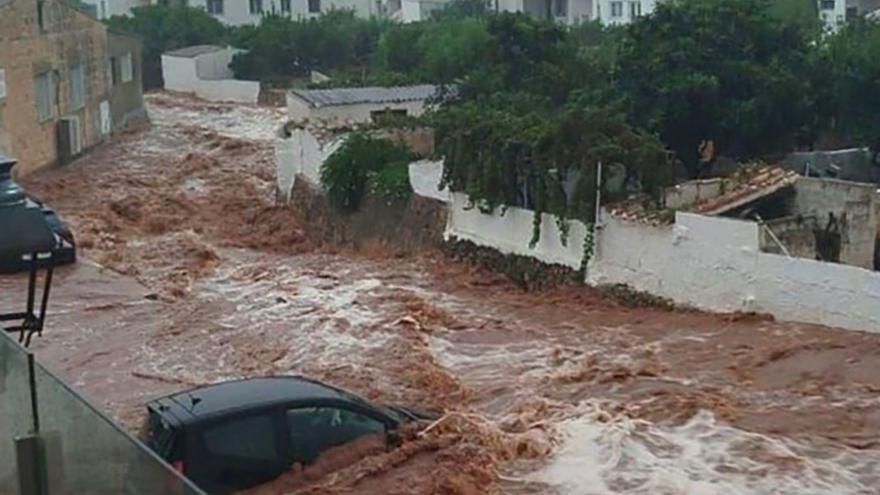
A powerful storm has unleashed its fury on the Mediterranean this week. The rain began to form in the Cantabrian region, intensified as it passed through Catalonia and reached the Balearic Islands with unprecedented violence. Between Wednesday and Thursday, several episodes of heavy rain, severe flooding and severe flooding were reported across the archipelago. In the town of Es Mercadal in Menorca, the storm left more than 200 litres per square metre in just a few hours, forming a large stream that washed away everything in its path and forced many people to evacuate.
It is too early to assess the facts, but everything indicates that the damage caused by the storm could be in the millions. But how could the rain have caused so much destruction? Perhaps the forecasts failed? Were the cities prepared for such a storm? Did the citizen’s preparation fail?
Just a week ago, the entire Mediterranean was engulfed in an intense heatwave that left, among other things, maximum temperatures of over 40 degrees in Cantabria and the Basque Country. But on Tuesday, something changed. Meteorological models, which study the behavior of the atmosphere across the planet, predicted the arrival of a large cold air current coming from the North Atlantic.
Notice from Emt
On the same day at 1:53 p.m., the State Meteorological Agency (Aemet) issued a “Special Warning of Adverse Phenomena” warning of the arrival of a major storm in the peninsula and the Balearic Islands. The forecast then indicated the risk of very heavy rain accompanied by hail and strong winds. The initial statement also warned that the phenomenon could pose a “serious risk to people” and that, in addition, its development was very difficult to predict.
Dozens of yellow and orange alerts were activated on Tuesday throughout the Pyrenees, from the Bay of Biscay to the Empordà, and practically throughout the Mediterranean, from the Catalan coast to Murcia and parts of Andalusia, as well as the entire Balearic archipelago. On Tuesday afternoon, Aymet activated the red alert, the highest, on the coast of Mallorca, warning of the arrival of a “very adverse situation” and asking residents not to travel there unless absolutely necessary.
For its part, the Balearic Government (PP) has also activated the storm alert, calling on the population to be “prudent and cautious” and asking “to take measures to prevent water from eventually entering homes and to avoid outdoor activities, at sea, or approaching boardwalks” during the episode, especially between Wednesday and Thursday.
Meteorologists were already warning about the severity of this storm, but despite this, it was extremely difficult, if not impossible, for them to predict its intensity in some areas. First of all, because this type of phenomenon is difficult to predict its development, which depends on a wide range of factors.
Related News
And secondly because, unlike other summer storms, this one is “fed” by the heat and humidity emanating from the waters of the Mediterranean, which just this week reached the highest temperature since records existed. “It’s like having an open can of gasoline,” Paco Martin, coordinator of the specialized meteorological magazine RAM, explained a few days ago, about the risk posed by the presence of a “boiling Mediterranean” and the repercussions this could have on the formation of storms.
In the specific case of the Balearic Islands, all the ingredients came together to create a particularly devastating storm. On the one hand, because the storm was loaded with energy when it reached the Mediterranean. On the other hand, because the island territory itself, due to its geographical location, is particularly vulnerable to stormy weather.

“Prone to fits of apathy. Introvert. Award-winning internet evangelist. Extreme beer expert.”


